Major Upgrades Announcement for UAS Program
May 20, 2026
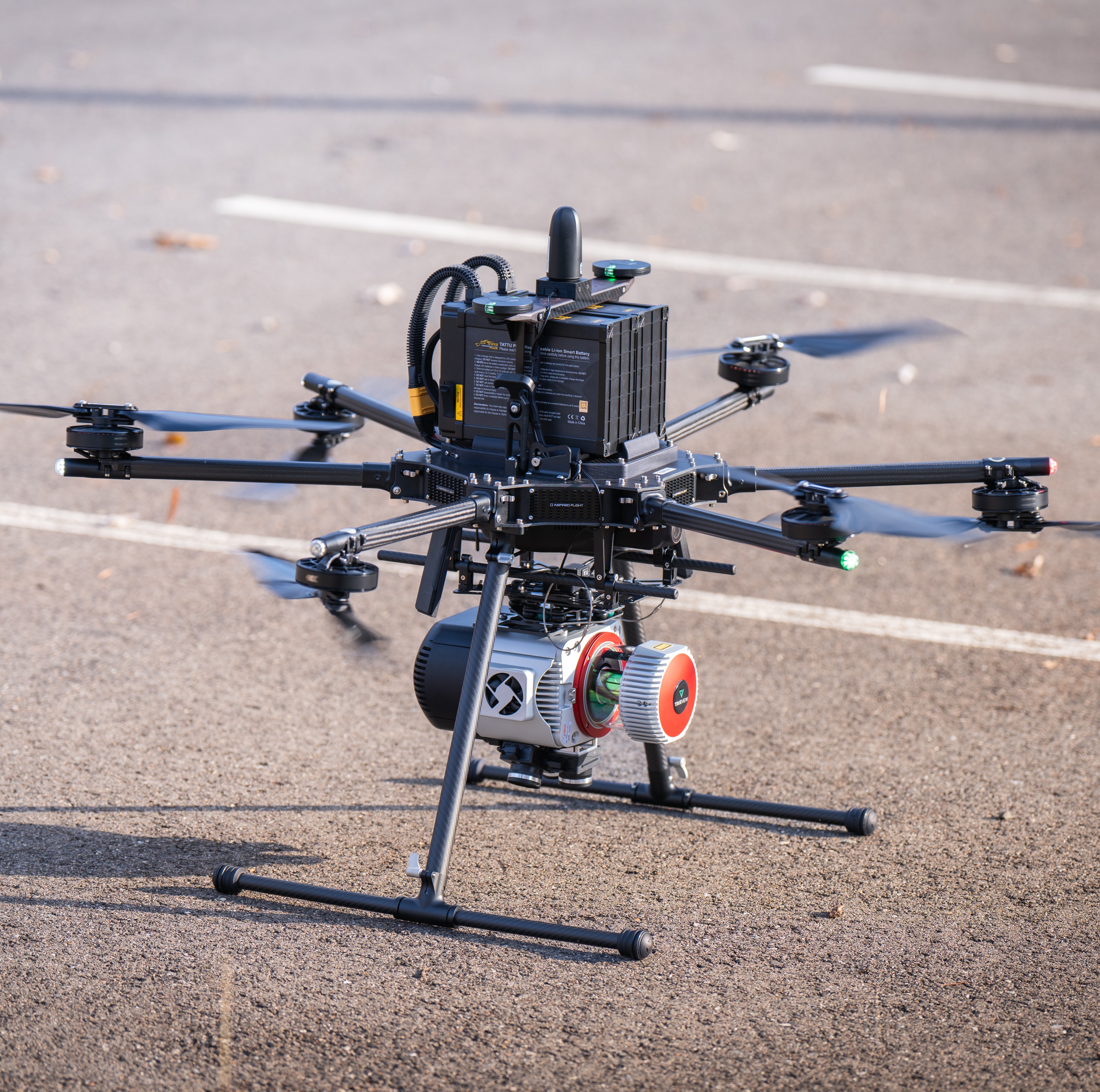
Rice announces major upgrades to their Unmanned Aircraft System (UAS) Program. Rice’s UAS Program is now anchored by Inspired Flight’s IF1200A Heavy-Lift Hexacopter with GeoCue’s TrueView 680 LiDAR Scanner with RGB Imagery, a combination producing survey-grade accuracy at 400 feet or more overhead. This UAS Program adds extensive new possibilities and options for any photogrammetry or LiDAR project. Previously, Rice’s FAA Part 107 pilots operated a fixed wing eBee unmanned aerial vehicle without LiDAR capabilities.
The hexacopter drone and onboard LiDAR are both fully NDAA compliant, a regulation banning any foreign manufacturing, ensuring the UAS program is trusted by both federal and state government agencies. Under optimal conditions, a single IF1200A flight can cover approximately 100 acres in one 20-minute battery cycle, capturing over 300 points per square meter. The 360-degree field of view onboard LiDAR sensor captures up to 90 degrees while mounted under the drone.
“This aerial system is a major investment, selected after months of research and testing,” said Rice Geospatial Services Manager Frank Sokoloski, CP, SP. “We coordinated with the Virginia Department of Transportation before purchasing and sent our licensed pilots out of state for a week of training with Inspired Flight instructors and GeoCue support staff. It’s been a careful and slow process, but we’re thrilled how everything came together.”
Rice staff are experienced and proficient in obtaining waivers, permissions, and clearances required for any surveying or mapping project, including airspace and flight requirements. Rice’s UAS Program can support and enhance a variety of projects, including:
- Transportation projects (infrastructure, roadway, railway, and more)
- Building conditions assessments
- ALTA boundary surveys
- Land development
- Photogrammetric imagery
The program is already airborne—the new UAS system has flown for official VDOT projects and in a demonstration for Fairfax County staff displaying the program’s 3D modeling and roof assessment capabilities.
To schedule a demonstration, contact Rice’s UAS Program Manger Ryan DeMarmels. Ryan has been with Rice since 2020, expanding his role from survey technician to UAS lead after championing the program upgrade.
UAS Program Contact
Ryan DeMarmels, UAS Program Manager
804.674.9723, rdemarmels@ricesurveys.com
Don't just take our word for it!
(But we do think we're pretty great!)
"Rice Associates’ versatility, flexibility, and responsiveness have made them a great asset to the team."
Senior Transportation Project Manager | WSP