

About Rice Associates
Rice Associates, Inc. (SWaM Certified #8406S) is a small woman-owned, geospatial services firm that provides conventional surveying, in-house photogrammetry, static, mobile, and terrestrial LiDAR scanning, building information modeling, and subsurface utility engineering.
Since our founding in 1986, we have been committed to delivering top-notch service to fit the needs of our clients. We have a strong desire to produce the highest quality deliverables to help our clients achieve success. At Rice Associates, we seek to employ professionals who share our values of high standards, dedication to quality, and remaining industry innovators.
Our main tool for success is our all, in-house capability. All services are performed in-house by our highly skilled and trained professionals thus allowing us to enhance quality, meet project schedule, and minimize cost.
We maintain a staff of over 50 highly qualified and experienced licensed surveyors, photogrammetrists, and field and office technicians located in three offices across the Commonwealth of Virginia.


LOCATIONS
With offices strategically located in Manassas, Richmond, and Virginia Beach, we have the ability to provide survey related services to clients throughout the Commonwealth of Virginia and the Washington, D.C. metropolitan areas.
WHO WE SERVE

With a staff comprised of highly qualified and skilled professionals, we are able to complete over 200 significant survey projects on an annual basis, with over 90 percent of this work performed in the Commonwealth of Virginia.
Our 30+ years of experience has presented us with a diverse range of project types allowing us to specialize in the following markets:
Highways
Bridges
Rail
Metro
Airports
Municipalities
Public Works
Federal
State & Local
Private Sector
Utilities
PORTFOLIO OF OUR WORK

High-Definition LiDAR Scanning - Chrysler Museum Glass Studio
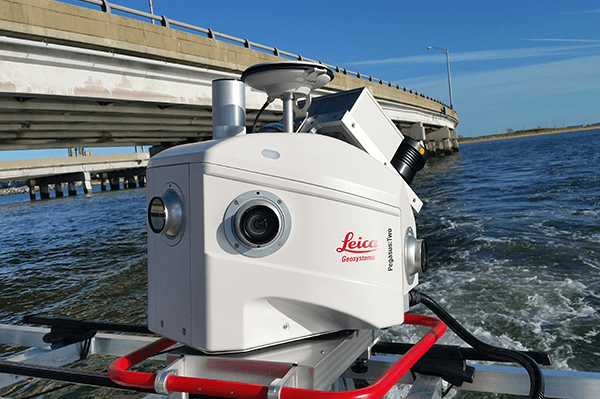
Hydrographic Survey and LiDAR Shoreline and Island Survey - Hampton Roads Bridge Tunnel

Laser Scanned High Definition Survey - Kings Dominion Amusement Park, Intimidator 305 Roller Coaster

Monitoring Survey - Monitor Merrimac Bridge Tunnel

Quality Assurance Survey and Review - Monroe Street, NE Bridge Over WMATA and CSX

Topographic Survey and Subsurface Utility Engineering - Pentagon Sentry Program, Boundary Channel Drive

Topographic and As-Built Survey - Ronald Reagan National Airport Express Ramp

Aerial LiDAR, Photogrammetric Mapping, and Ground Control Survey - Southeast High Speed Rail (Richmond to Potomac Segment)

Bridge Situation Survey - Rt. 11 Crossing Cedar Creek, VA

Topographic and As-Built Survey - Arlington National Cemetery Millennium Project

Comprehensive Photogrammetric Location Survey - Interstate 66

LiDAR Scanning - SR-71 Blackbird Relocation Project